The Commonwealth Scientific Industrial Research Organisation (CSIRO) in Australia is examining thermal imagery of the Indian ocean from several additional satellites to measure the temperature of the surface of the ocean in the hunt for missing Malaysian Airlines Flight MH370.
Scantherma produced a graphic commissioned by a global insurance company
According to CSIRO oceanographer David Griffin, satellites are continuously monitoring the ocean. The principal ones for this investigation are European and US sea-level measuring satellites, reports the BBC. "We're also using thermal imagery of the ocean to see the details of what the flow has been," says Griffin.
Aviation Week previously turned up additional details, saying that Australian remote sensing and thermal imagery company Scantherma produced a graphic commissioned by a global insurance company to find debris from the missing Boeing 777-200ER, which puts the search for Malaysian Airlines flight MH370 into a clearer context.
Scantherma is using ‘object-based image analysis’ techniques to distinguish between random sea flotsam (like crates and debris from spilled containers), actual containers themselves and white caps.
Further analysis of some earlier satellite imagery which purported to show fields of debris now appear to show white specs which were in fact breaking waves in rough seas.
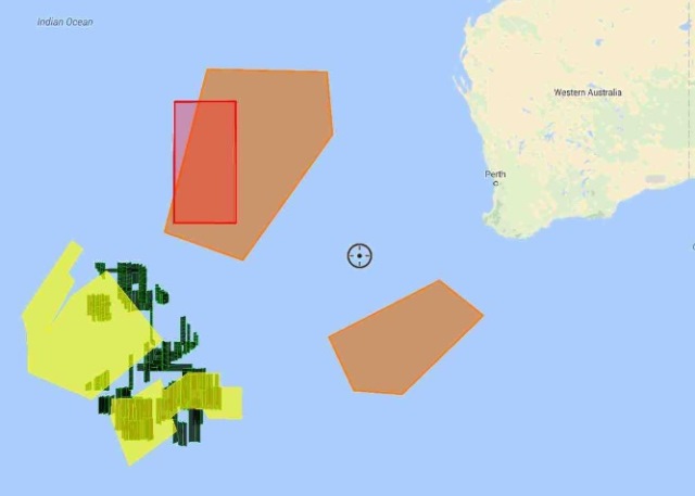
Orange areas are new search zones while the red area is the newly allocated search zone designated by the Australian Maritime Safety Authority AMSA after further evaluation of earlier radar tracking data showed the 777 was flying close to Mach 0.86-0.87 speed.
According to The West Australian website, Scantherma analysed 437 images of debris in the original southern Indian Ocean search area, before shifting their focus north-east based on ocean current data.
"There was plenty of debris in those first 437 images but it wasn't from the plane," said Scantherma chief executive Amir Farhand.
"It was mostly white caps and sea junk. Global shipping lanes pass through that area to the south of Western Australia.” He added that Scantherma's chief remote sensing analyst was stationed in Florianopolis, Brazil.
Water Encyclopedia describes physical oceanography as utilising a number of scientific specialties and studies that encompass technologies from echo-sounding determinations of seafloor structure and seismic studies of movements in oceanic crust to satellite estimations of current flow based on radar reflections and thermal imaging.
For more on thermal imaging cameras, please visit Tester.co.uk.